Road Reports
Highway 52 Road Conditions
BC Highway 52 Road Conditions for Highway 52 North from Tumbler Ridge through Feller Heights to join Highway 97 west of Arras and Highway 52 East from Tumbler Ridge connecting with Hwy43/ Highway 2 near Tupper.
Hwy 52 East Road Report
Hwy 52 North Road Conditions

Tumbler Ridge – Highway 29 and Highway 52 intersection in Tumbler Ridge Looking to the West on Hwy 29. For other Highway 52 Cameras check Highway 2/52 intersection at Tupper.
Highway 52 is known locally as the Heritage Highway, is a long alternate loop route between Arras, on the John Hart Highway 97 just west of Dawson Creek, and Tupper, on the B.C.-Alberta border. The community of Tumbler Ridge is in the center of the loop so to speak 98 km (61 mi) south of Arras and 145 km (90 mi) south of Tupper. Highway 52 Road Conditions
Mount Washington Road Conditions
Vancouver Island Mount Washington Road Conditions
Road 40 Road Conditions
BC Road 40 Road Conditions reports for the Lillooet-Pioneer Road as reported by DriveBC’s data feed.
| Road 40 (Lillooet-Pioneer Rd). Debris on roadway between Tyaughton Lake Rd and Yalakom Rd for 60.9 km (87 to 26 km west of Lillooet). Construction work. Watch for traffic control. Expect delays. Light traffic only, limited road widths. minor incident | last updated Tue Apr 21 at 1:03 AM PDT. |
BC Highway 40 runs for just over 100 kilometers from the town of Lillooet to a tiny community of Gold Bridge. The route starts in Lillooet where Moha Road begins off Main Street. Shortly, Moha Road turns into Bridge River Road (also known as Lillooet-Pioneer Road). Finally, at Terzaghi Dam, Carpenter Lake Road along Carpenter Lake takes over as Highway 40 all the way to the town of Gold Bridge.
BC Highway 40 starts in the town of Lillooet, and there are two ways to get there from Vancouver: first is Highway 1 East to Lytton via Fraser Valley-Hope-Yale-Boston Bar, then take Highway 12 from Lytton to Lillooet. Or Highway 1 West to Horseshoe Bay, then Highway 99 (Sea-to-Sky) via Squamish-Whistler-Pemberton to Lillooet. If driving on Highway 97 South towards Cache Creek, turn right onto Highway 99 a few kilometers before Cache Creek, and you’ll get to Lillooet that way also.
Highway 99 Road Conditions Reports
Highway 12 Road Condition Reports
If you travel route 40 you may want to interact with other travellers by reading the Road Conditions Lillooet-Pioneer Road 40 Facebook page.
Highway 395 Road Conditions
BC Highway 395 Road Conditions Report for the the Christina Lake Laurier Highway.
British Columbia Highway 395 is a short cross-border spur in the Regional District of Kootenay Boundary in British Columbia. It connects with U.S. Route 395 (from which it derives its number) at the Canada–U.S.border crossing near Laurier, WA to the Crowsnest Highway (Highway 3) near Cascade, about 20 km (12 mi) east of Grand Forks.
Highway 395 is a continuation of U.S. Route 395 in Washington State, which is a major highway.
The Laurier–Cascade Border Crossing connects the town of Kettle Falls, Washington with Christina Lake, British Columbia on the Canada–US border. This crossing is the point at which the road signed as US Route 395 on the American side and British Columbia Highway 395 on the Canadian side.,
The Kettle River, the Canadian Pacific Railway, and the runway of the Avey Field State Airport all traverse the Canada–US border. Highway 395 Road Conditions
Insert: Laurier Wa webcam here
U.S. Route 395 is an American highway route in the western United States.
The southern end of Hwy 395 is located in the Mojave Desert at Interstate 15 near Hesperia.
The northern terminus is at the Canada–US border near Laurier, where the road becomes Highway 395 upon entering British Columbia
Hemlock Valley Road Conditions
Hemlock Valley Road Conditions report
The Ministry of Transportation and Infrastructure requires that all vehicles, including 4X4s, carry proper fitting snow chains in their vehicles when travelling on Hemlock Valley Road.
Road Condition Reports for BC Highway 7
Sasquatch Mountain Resort – Ski Hemlock Valley
- Take Hwy #1 east to Abbotsford
- Take the Sumas exit for Hwy #11 North to Mission
- Cross the Mission bridge and follow the signs for Hwy #7 East
- Turn left on Morris Valley Road (Sasquatch Inn)
- Follow the road all the way to the fork in the road at the Sasquatch Mountain Resort sign
- Turn left onto Hemlock Valley Road, and follow the road up to the Day Lodge. Hemlock Valley Road Conditions

Airport Way
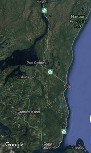
Haida Gwaii – Weather Cams
Haida Gwaii weather cams for Haida Gwaii Road Conditions

Masset – Hwy 16 at Hodges Road in Masset on Haida Gwaii, looking north.

Tlell – Hwy 16 at Wiggins Rd, on the east coast of Graham Island, looking north.

Skidegate – Hwy 16 at the ferry terminal on Haida Gwaii, looking north.
Ocean View Drive Report:
Haida Gwaii: Road Condition Report and for all of BC Highway 16
For more info on Haida Gwaii visit https://www.indigenousbc.com/
BC Ferry Schedule to Prince Rupert
Highway 6 NS Conditions
BC Highway 6 NS Conditions report for the Nelson Nelway Highway. Conditions for Highway 6 EW
| Highway 6 NS, in both directions. Watch for falling rocks between Junction Hwy 31A and Springer Creek Rd for 31.5 km (New Denver to 1 km south of Slocan). minor incident | last updated Wed Mar 25 at 4:03 PM PDT. |
BC Road Conditions for Highway 6 EW
Highway 6 is a two-lane highway passing between the Kootenay and Okanagan regions in the province of British Columbia, Canada. It is divided into two parts—the Nelson-Nelway Highway between the Canada–US border and Nelson, and the Vernon-Slocan Highway between South Slocan and Vernon. Source Wikipedia
Highway 6 begins at the Canada–US border crossing at Nelway, where it connects with Washington State Route 31. The highway parallels the Salmo River for the rivers entire length from Nelson to the border and many views of the river can be seen from the highway. From the US Border, it travels north through the Selkirk Mountains for 10 km (6 mi) to the Burnt Flat Junction, where the Crowsnest Highway (Highway 3) merges onto it from the east. Highway 3 and Highway 6 share a concurrency north for 14 km (9 mi) to the town of Salmo, where Highway 3 diverges west.
From Salmo, Highway 6 goes north for 10 km (6 mi), continuing to follow the Salmo River valley to the town of Ymir. Then it continues north for 34 km (21 mi) passing through the communities of Porto Rico and Hall Siding, to the city of Nelson, just south of which (10 km) access to the Whitewater Ski Resort is located. Highway 3A merges onto Highway 6 in Nelson, and the two highways travel west for 24 km (15 mi) along the Kootenay River, passing through the communities of Taghum, Bonnington Falls, Beasley and Corra Linn to where Highway 3A diverges southwest just west of South Slocan at Playmour Junction. The highway then proceeds north west up the Slocan Valley.
From South Slocan, Highway 6 follows the Slocan River north for 75 km (47 mi) passing through Winlaw, Slocan City and Silverton to the community of New Denver, where Highway 31A meets Highway 6. 46 km (29 mi) northwest of New Denver, Highway 6 reaches its junction with Highway 23 at the resort community of Nakusp. Highway 6 then turns southwest and proceeds to follow the east bank of the Columbia River (Lower Arrow Lake) for 60 km (37 mi) to Fauquier, on the east shore of Lower Arrow Lake, where the Needles Ferry is located.
List of BC Highway Numbers / Names
- Adams Lake Ferry
- Airport Way
- Arrow Park Ferry
- Athalmer Rd
- Atlin Hwy
- Barnston Island Ferry
- Big Bar Reaction Ferry
- Blackwater Rd
- Boulder St
- Cecil Lake Rd
- Coalmont Rd
- Corbin Rd
- Dicken Rd
- Dog Creek Rd
- Fording Mine Rd
- Francois Lake Ferry
- Glade Ferry
- Harrop Ferry
- Head Bay Rd
- Hemlock Valley Rd
- Highway 1
- Highway 1A
- Highway 2
- Highway 3
- Highway 3A
- Highway 3B
- Highway 4
- Highway 4A
- Highway 5
- Highway 5A
- Highway 6 EW
- Highway 6 NS
- Highway 7
- Highway 7A
- Highway 7B
- Highway 8
- Highway 9
- Highway 10
- Highway 11
- Highway 12
- Highway 13
- Highway 14
- Highway 15
- Highway 16
- Highway 17
- Highway 17A
- Highway 18
- Highway 19
- Highway 19A
- Highway 20
- Highway 21
- Highway 22
- Highway 22A
- Highway 23
- Highway 24
- Highway 26
- Highway 27
- Highway 28
- Highway 29
- Highway 30
- Highway 31
- Highway 31A
- Highway 33
- Highway 35
- Highway 37
- Highway 37A
- Highway 39
- Highway 41
- Highway 43
- Highway 49
- Highway 51
- Highway 52
- Highway 62
- Highway 77
- Highway 91
- Highway 91A
- Highway 93
- Highway 95
- Highway 95A
- Highway 97
- Highway 97A
- Highway 97B
- Highway 97C
- Highway 97D
- Highway 99
- Highway 99A
- Highway 101
- Highway 118
- Highway 395
- Horse Lake Rd
- Horsefly Rd
- Horsefly-Likely Rd
- Jaffray-Baynes Lake Rd
- Kicking Horse Trail
- Kikomun Rd
- King St
- Kootenay Lake Ferry
- Likely Rd
- Little Fort Ferry
- Lytton Ferry
- Maple Dr
- McLure Ferry
- Mission Rd
- Morris Valley Rd
- Mount Washington Rd
- Mountain House Rd
- Needles Ferry
- Nazko Rd
- Nisga’a Hwy
- Ocean View Dr
- Port Mellon Hwy
- Road 40
- Telegraph Creek Rd
- Toby Creek Rd
- Upper Arrow Lake Ferry
- Usk Ferry
- Wardner-Fort Steele Rd
- Westcoast Rd
- Westside Rd
- Wycliffe Park Rd
- Wycliffe Rd
- Other Roads